Trinidad and Tobago Department of Geography The University of the West Indies, St. Augustine Behavioral Science
I observed how the 2007 earthquake off the coast of Martinique changed people’s perceptions in Barbados towards earthquakes. Then, I thought about natural disasters like hurricanes and wildfires that people know are coming and wanted to find out more about why populations act or do not act. By participating in the first ISR readiness exercise, I could see the usability of my work and its impact on a real-life situation — a phenomenal feeling.
I was impressed by the inclusive way that the ISR opened its first readiness exercise. The issue of air quality in public health, as part of crisis preparation, is very important and yet understudied in my country. I couldn’t pass up submitting a proposal.
Australia The Australian National University Paleoecology
I want my research to also help people, to contribute to humanity, because directly or indirectly ecological crises affect people’s lives. The ISR’s first readiness exercise gave me a way to think about my research interests and areas of expertise from another perspective that explores multidisciplinary approaches.
Brazil Scientific Director of Microbiote Fundação Arthur Bernardes/Petrobras, Universidade Federal de Viçosa Microbiology
As scientists, we can prevent real crises. The ISR allows us to think in advance, think about the future. When a crisis arrives, we can have strong projects or concepts that are ready to help mitigate disasters.
International Science Reserve community member Daniel San Martin shares how he is applying his research in scientific computing to wildfire preparation and response.
In any major climate-related crisis, access to geo-spatial-temporal datasets, mapping, modeling, and analytical tools are critical to aid recovery efforts and protect communities. Many expert researchers, especially scientists and institutions in low-to-middle income countries, lack the tools to access and analyze relevant data, to inform local decision makers on how to act rapidly and effectively.
During a recent panel with the Predictive Analytics World (PAW) climate conference, we spoke with ISR community member Daniel San Martin of Universidad Técnica Federico Santa María in Chile. Daniel specializes in scientific computing with a current research focus on computational fluid dynamics, numerical methods, and high-performance computing applied to forest fire modeling.
How are you using data to inform crisis preparedness and decision-making on wildfires in your region?
Our work is not only based on data, but we also use physical models and simulations to get or evaluate dangerous zones and vulnerable locations. Our approach is to use these simulations to make informed decisions for experts in disaster management, like government institutions. We can also use the models to create new data for AI-based models in order to complement the analysis. The main contribution of our work with wildfires is trying to best inform the people who make the decisions and try to minimize the damage of wildfires.
Why did you look for collaborations outside of Chile, and why is a global network like the ISR beneficial to your work?
I think collaboration with a global network is crucial for developing countries, like Chile. We do this to tap into diverse expertise and to gain a global perspective, specifically on disasters. Also, to share resources and build capacity for rapid response. I think different experts in disaster management approach this work in order to help shape policies. I strongly believe that global collaboration is mandatory nowadays to face any kind of disaster, even more so now that we are suffering the effects of climate change.
How does access to resources, like geospatial mapping and modeling, impact your research and work?
In terms of data, it is really tricky in my region because of the availability of the technology or the funding to get intelligent data, like they have in the United States. We have a lot of resource constraints, such as spatiotemporal resolution issues, data integration complexities, sharing restrictions, data quality concerns, resource constraints, and remote sensing limitations, among others. Usually, we try to use the data provided by US or European institutions. We use that data to create models, but it cannot always be applied because we have geographical or meteorological differences. We need data and tech development by other countries, to create or adjust the tools to our own context.
What more could be done for researchers like yourself to get the data you need, and communicate it to decision makers?
To better support researchers in disasters, enhanced data accessibility through open initiatives and real-time streams is crucial. This includes advocating for standardized formats and integrating advanced remote sensing technologies. To communicate findings effectively to decision makers, user-friendly visualization tools and comprehensive scenario analysis reports are essential. Collaborative engagement with stakeholders, including regular workshops and educational initiatives, can bridge the gap between researchers and decision-makers, fostering understanding and trust.
Additionally, advocating for policy integration and offering training sessions to decision makers can ensure that scientific research is considered in disaster management strategies, ultimately enhancing the impact of simulation models on informed decision-making.
With experience in AI and quantum computing as well as innovative practices to advance and protect American workers, Chike Aguh brings a lot to the International Science Reserve (ISR).
The International Science Reserve is pleased to announce that Chike Aguh, former Chief Innovation Officer at the U.S. Department of Labor, has joined ISR’s Advisory Council.
Under the Biden administration, he led efforts to use data, emerging technologies such as AI and quantum computing, and innovative practice to advance and protect American workers. We sat down with him to talk about what he learned from previous crisis response experiences and why it’s not a time for business as usual.
As an advisor to the ISR, you are applying your expertise in data innovation to ensure that scientists worldwide have the resources to prepare for and respond to the next crisis, such as climate-related disasters or the next pandemic. What role do you believe data and innovation can play in crisis response?
Chike Aguh
Data and innovative technology or practice are critical to crisis responses, respectively. During the fast-moving times of a crisis, data that can tell us what is happening and what has happened previously can be scarce. Who has access to data can be a life-or-death situation: people or governments who have it will weather the storm and those who don’t will be swept away by it. Whether it is mapping what symptoms people are searching on Google to determine what type and where pandemics may spring up, to analysis of large research data sets to mitigate these crises, data helps increase the confidence interval of the interventions that leaders must take to keep us all safe.
Whether practice or technology, innovations are also indispensable during a crisis because the general operating procedures generally do not have the scale or speed required to stay ahead of the crisis. Innovations allow us to operate at “the speed of the fight” as my old boss, US Army General Stan McChrystal used to say.
At ISR, we help researchers connect to emerging technologies and resources for collaboration across borders to address the worst impacts of crises. What are some lessons from your time in the Biden administration that could apply to researchers in ISR’s network?
The lessons I learned were elegant and devastating in their simplicity. One, even the most cutting-edge technologies are not a replacement for strategy. Leaders must do the hard intellectual work of identifying the key problems and questions to be solved in a crisis. Only then can these technologies be applied intelligently and effectively.
Two, sociology will overwhelm technology every time. In the space of collaborative research, we can only achieve the collective brilliance of all involved if we have the goodwill and effective means of working together.
And three, the most important power of these technologies is to help us think outside the parameters of normal practice and try things we would never attempt in normal times. We should not simply use these technologies to do the same old things with incrementally better speed or effectiveness, but rather use them to take quantum leaps in impact.
You once said that for any problem we are solving, “Those problems cannot be solved by any one person, one organization, or one sector alone.” Do you believe that more people are thinking and operating through a lens of collaboration in the aftermath of the COVID-19 crisis? What more could we do to implement this new way of working within crisis response?
I do. Some of the greatest successes of the COVID-19 response, from vaccine development, testing innovation, treatment deployment, to the High-Performance Computing Consortium (HPCC) show what is possible when traditional siloes are sublimated for the sake of helping everyone.
The key question is: how do we make this new collaborative lens not simply a feature of crisis response, but a key part of operating procedure for all of us? My biggest recommendation is to keep the institutions that we have created like the HPCC running. Then, they can be applied not simply when responding to crises but can help prevent crises before they ever start.
ISR pre-positions resources, like high-performance computing, remote sensing, and geospatial models, so that scientists can connect to them quickly across borders to address the worst impacts of a crisis, without a long wait or extensive application. Why should businesses make data innovations more available to researchers worldwide during crisis?
When crisis events like COVID-19 occur, we have seen the impact on the economy and how it hits the bottom line of businesses. It is in a company’s best interest to do anything it can to fight and end these crises as quickly as possible, and that means making data and cutting-edge technology available to the scientists who are working on just that.
Secondly, I also believe that business and business leaders feel a sense of duty to their communities and their countries. This is a tradition that we have forgotten but one can go back to businesses like Bell Labs, who helped develop critical technologies like radars that helped during WWII. We need to remember and keep this tradition alive now. Business and the world will benefit as a result.
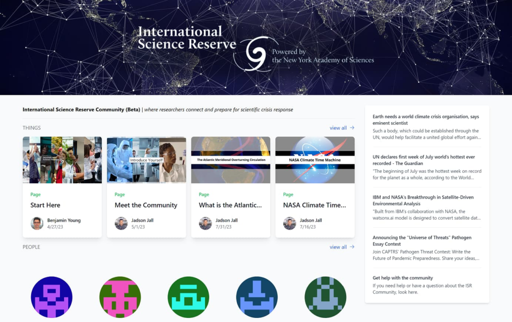
Earlier this year, the ISR launched a Beta version of a free, digital hub for the 4,000+ scientists in the ISR network. The ISR Community builds on the learnings from our first readiness exercise in 2022, a test case around wildfires, where we asked scientists to submit proposals for how they would manage a cross-border wildfire crisis and consider what tools and resources they would need.
Jadson Jall
In the wildfire test readiness exercise and throughout our ongoing conversations, ISR members were clear about the need for interdisciplinary, cross-geographic collaboration, and for easier and faster ways to engage in preparedness. We heard you. That’s why we built the ISR Community and have been working closely with Beta testers to ensure it is effective across disciplines and regions. A full, network-wide launch is expected in Fall 2023.
Recently, we sat down with Jadson Jall, the ISR’s first Science Community Manager to learn more about the digital hub’s progress. Jall is a geneticist from Brazil and has a passion for bringing scientists together to unlock the power of scientific collaboration as a key to solving humanity’s greatest challenges.
Why do you think the global science community needs a network like the ISR now?
The global science community needs a network like the ISR because we live in a world with many compounding crises, such as pandemics and climate-related disasters. These crises are huge, affecting people and the environment in different countries and regions, and they are complex. That means they need lots of different kinds of responses and resources. So, one country’s scientific capabilities, or a single national science policy, can’t begin to resolve crises at that scale. An open, global network of scientists, such as the ISR, means individuals and institutions can pool resources and solve problems together, leading to faster and more effective responses to crises. Furthermore, the network’s principles, such as bringing together Scientists Without Borders and ensuring fair resource access, promoting collaboration, and including different voices, make it a much-needed platform for the current global scientific community.
What would you like the ISR’s digital hub to look like a year from now, and how would scientists be using it?
In my dream world, a year from now, the International Science Reserve (ISR) hub would be a globally recognized and effectively functioning platform facilitating seamless personal connections and collaboration among scientists worldwide. It would have grown beyond its current network, and its resources would be even more diverse and plentiful. Scientists would use the hub to conduct and participate in readiness exercises and explore crisis scenarios, helping them prepare for various kinds and aspects of disasters and emergencies. The hub would also be a place where scientists would know where to go and how to apply to connect to different scientific and technical resources in different situations. Ideally, the hub would have a track record of successful crisis response efforts. That will demonstrate its effectiveness and reinforce its value, most importantly, by having a positive impact.
Can you share more about how you see early adopters using the online community, and their feedback? What do they want to see more of?
Active community pioneers – our earliest testers – engaged in discussions on diverse topics, from climate change crisis simulations to challenges in research collaboration. Our testers from varied locations and research backgrounds provided invaluable feedback, helping us to consistently refine our virtual environment to better foster scientific engagement and collaboration. For example, they helped us figure out which formats could work for the ISR’s Readiness Exercises and helped us try out various types of activities and collaborations. During the current Beta phase of the ISR Community, we continue to learn from our early adopters. It is clear that our community is eager to collaborate across borders, and I am doing my best as Community Manager to facilitate these connections and collaborations.
Why did the ISR choose to use “serious games” as an approach to crisis readiness? And how will the readiness exercises work in the ISR Community?
The ISR chose to use serious games as part of crisis readiness because it’s a fun way to learn about and improve the decision-making process, so that participants can feel they are undertaking the process themselves. Role-playing puts the participant in the position of learning about the crisis in real time and actively experiencing the dilemmas and decisions of how to respond, rather than learning about it afterward. These scenario-based simulation exercises allow researchers and decision-makers to practice analyzing available, often limited, information and making the best decisions, as quickly as possible.
Serious games will help members of the ISR Community explore decision making around issue areas such as water resource management, climate change adaptation, weather disasters, public health crises, and urban planning. These games serve as a hands-on and immersive way to understand the complexities and nuances of various crises and try different strategies for dealing with them.
The ISR’s serious games will be conducted online, in a collaborative, interactive format. These exercises will simulate various real-world crisis scenarios, and participants will devise and implement strategies to manage these crises. The activities are being designed to help participants better understand how resources will be deployed and managed in future crises and explore related decisions, helping to prepare us for scientific work in times of global crisis.
What kinds of resources are available to researchers in the ISR Community?
The ISR Community offers a rich suite of resources to its community of researchers and other stakeholders. They can be organized around two main areas. The first of these consists of specialized scientific resources such as high-performance computing, remote sensing, geospatial-temporal mapping, and databases. The ISR partners with organizations like IBM, UL Solutions, Google, Pfizer, and the National Science Foundation, offering various technical tools, data, and other resources. During a declared crisis, researchers will be able to log on to the ISR Community to gain access to resources like IBM’s Geospatial Discovery Network.
The other key resource of the ISR Community is our global network of over 4,000 scientists who have come together around a common goal. The ISR Community provides a space for this growing network to prepare, learn, collaborate, and be ready for crises. We will be offering different types of preparedness activities to help facilitate some of the community’s collaborations, and we are also planning special features for the fall based on the interests of the community.
One last question: why should your fellow scientists join you on the ISR Community?
I recommend that my fellow scientists join me in the ISR Community for a multitude of reasons, including:
Joining is completely free, and you will receive global exposure and appreciation for your contributions to crisis resolution. Being part of the ISR is a unique opportunity to apply your research in a real-world context, contributing to tangible crisis solutions.
As a member of the ISR Community, you will be part of a borderless network of experts, allowing for valuable collaborations and exchanges of ideas. It’s also an excellent space for professional development, offering opportunities for knowledge sharing, networking, and building community connections.
Being part of the ISR Community ensures that you stay in the loop, with critical crisis communication updates.
So, the ISR Community is not only an opportunity to contribute to global crisis resolution but also a chance to grow professionally and expand our scientific horizons.
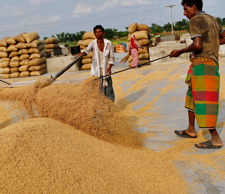
The International Science Reserve convened an expert panel to talk about the role of data in preparing for and responding to potential food system crises.
The world has enough food to feed everyone, yet the World Food Programme estimates that 345 million people around the world remain acutely food insecure in 2023.
Potentially further escalating this inequity, climate shocks are increasing the risks to agricultural yields. Heavy rainfall, droughts, and heatwaves can cause crop failures; climate and environmental pressures can decimate insect populations and microorganisms vital to plants and soil or let new crop pests or diseases emerge. Combined with a globalized distribution system and geopolitics, food system disasters are a compound problem.
To plan for or reduce the impact of these catastrophes, a variety of datasets, modeling, and analytical tools will be key, including observational data, remote sensing, geospatial mapping, and satellite imagery.
The International Science Reserve convened an expert panel from nonprofit and corporate perspectives across disciplinary and geographic boundaries to talk about the role of data in preparing for and responding to potential food system crises, as part of the International Science Reserve’s webinar series, Science Unusual: R&D for Global Crisis Response. Participants were:
Michael Hinge, Senior Economist, ALLFED (Alliance to Feed the Earth in Disasters)
Levente Klein, Research Staff Member, IBM
Kyriacos M. Koupparis, Head, Hunger Monitoring Unit, United Nations World Food Programme
Kay Sun, Senior Scientist, Mondelez International
Vaishnavi Chandrashekhar, Climate and Environmental Journalist, panel moderator
Here are the top takeaways from the discussion:
Participants agreed about the urgent priority to get accurate data about what’s happening with food systems, weather, and climate patterns:
The information needs to include a wide range of data inputs to make sure it includes the “ground-truthing” from sources where people are seeing the most immediate impacts.
And in turn that the information, modeling and predictions should be made available to the communities who are most affected.
The panelists talked about climate impacts on specific food crop examples and ways that data-based planning can help deal with those impacts with alternative food sources or adapting agricultural cultivation methods.
This first-of-its-kind partnership will help the international scientific community in responding to crises, such as climate-related disasters.
Published January 9, 2023
By Mila Rosenthal, PhD
As part of our ongoing mission, the International Science Reserve (ISR) works to facilitate access during a crisis to specialized scientific and technical resources from public and private institutions. Over the last year, the ISR has interviewed dozens of members of our network – from Trinidad to Argentina – to hear directly from them about what they need to more effectively do their jobs.
Access to real-time, complex, and global data sets and modeling was often top of their lists. For example, if a Turkish wildfire researcher in hydrology is collaborating with a soil agronomist across the border in Greece in responding to regional wildfire disasters, the team needs stronger data resources. More complex data will help them to understand wildfire spread related to water and land use patterns and it can contribute to advance plans to limit future damage across borders.
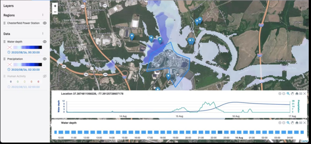
IBM’s Geospatial Discovery Network
This is where the ISR can help fill in the gaps. Scientists face multiple barriers to conducting applied research in times of crisis – especially in contexts and countries where funding is inconsistent and advanced data resources are limited. IBM and the International Science Reserve are partnering to increase access to specialized, curated data and analytics during global crises. This first-of-its-kind partnership will help the international scientific community in responding quickly and effectively to crises, such as climate-related disasters.
IBM will offer its Geospatial Discovery Network (GDN) – a set of data and information discovery and modeling technologies designed to anticipate environmental disruption and manage risk – to support the ISR’s scientific network in addressing the worst impacts of disasters, such as damage to people, communities, and livelihoods from heatwaves, wildfires and flooding. GDN’s data resources originate from IBM’s Environmental Intelligence Suite, and include hundreds of geodata sets from sources like satellite imagery, to which IBM applies analytics and AI for modeling.
Helping Businesses Improve Sustainability
We know that access to this type of data works. For nearly a decade, IBM has been helping businesses improve sustainability and manage the negative impacts of the changing climate, including:
IBM and the ISR plan to offer access to the IBM Geospatial Discovery Network to ISR’s network of researchers, at no cost, through a customized, fast-tracked process. When the ISR declares a crisis, scientists in the network will be able to apply to use the tools for projects that involve transnational research collaboration. In the coming months, we will offer scientists in our network the chance to explore crisis scenarios and simulations in which they could use IBM’s GDN tools and to practice submitting proposals through the new application process
We at the ISR are grateful to IBM for stepping up to reduce the red tape and break down borders to increase access to high-quality data and modeling tools for more researchers.
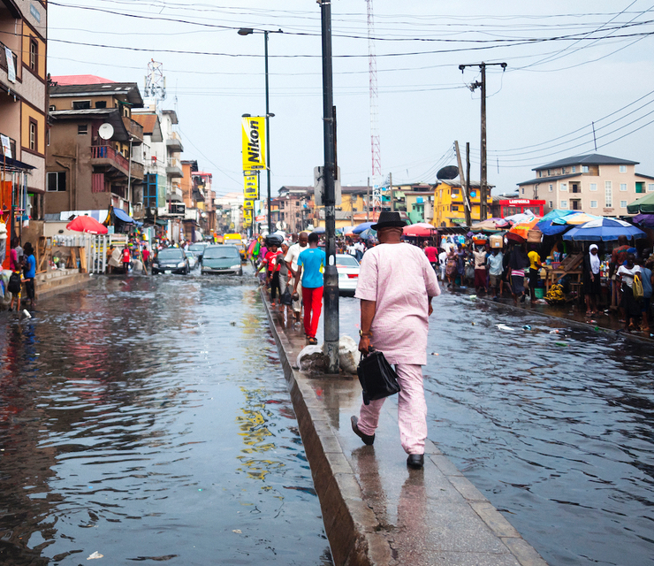
Around the world, flooding is wreaking havoc on people’s daily lives with increasing magnitude and frequency. Communities in Nigeria, Chad, Niger, Burkina Faso, Mali, and Cameroon are experiencing some of the worst floods in a decade, as they sweep across western and central African borders.
In Pakistan, the Philippines, Vietnam, Australia, and the United States—such as in Florida and Kentucky—communities have faced multiple dangerous and deadly floods in 2022. These unprecedented flood events have killed thousands of people, displaced millions, decimated farms and businesses, and destroyed homes and habitats.
The World Bank reports that about one and a half billion people are at risk from flooding, one-third of whom are living in poverty, making them more vulnerable to migration pressures and economic insecurity. While flooding can be a natural phenomenon that can help provide fertile soil and sustain wetlands, today’s floods are becoming more frequent, dangerous, and deadly, as a result of human-caused climate disruption and development in urban, coastal areas.
When flood water crosses national borders, “transboundary floods” can be even more catastrophic without international cooperation around emergency management, such as early warning systems. In a recent Science Unusual webinar, hosted by the International Science Reserve, a group of panelists explored the role scientific and technical experts can play in large-scale, international flood prediction, prevention, preparation and response.
Speaking on the panel were:
Nora El-Gohary, Professor of Construction Engineering and Management, The Grainger College of Engineering, University of Illinois Urbana-Champaign
Njoki Mwarumba, Assistant Professor of Emergency Management and Disaster, University of Nebraska Omaha
Anthony Torres, Chief Meteorologist and Head of Global Science Operations, Currently weather service
Campbell Watson, Senior Research Scientist – IBM Research, Global Lead, Accelerated Discovery—Climate & Sustainability
Ugochi Anyaka-Oluigbo, Environment and Conservation Journalist, Nigeria (Moderator)
Here are three big takeaways from the discussion:
1. Breaking down borders between social scientists and other types of scientists who study floods will lead to better outcomes for people and communities.
Njoki Mwarumba kicks off the discussion on why we need to break down siloes.
Nora El-Gohary on how scientists can help reduce the impacts of floods on infrastructure.
2. Using atmospheric data to predict flooding impacts is just the beginning. Protecting the most vulnerable requires a stronger analysis on how the atmosphere interacts with oceanic and local land systems, and human habitats.
Anthony Torres on where meteorology interacts with other disciplines and AI to predict floods.
3. Scientists should work to understand indigenous knowledge in order to better collaborate on early warning systems that save lives.
Njoki Mwarumba discusses the impact of leaving entire regions out of advances in technology, like early warning systems.
Anthony Torres on building two-way streets of communication between communities and scientists.
4. Artificial intelligence is enhancing our ability to predict and prepare for floods. But we must simplify access to increasingly complex data processes and improve their usage across borders.
Campbell Watson shares his thoughts on AI and its impact on flood modeling.
Campbell Watson discusses how IBM is researching and responding to global floods.