Storm Surge Barriers for New York Harbor?
As 21st century climate change accelerates the rise of sea levels, what could a monster storm like Hurricane Katrina do to low-lying coastal regions—such as New York’s?
Published November 1, 2005
By Christine Van Lenten
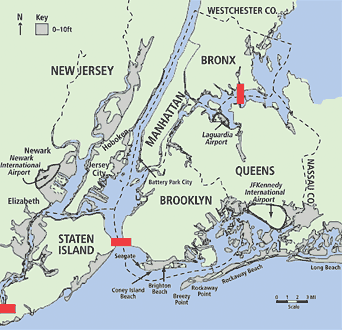
New York City has roughly 580 miles of coastline. The metro region has many times as much. Within the region, roughly 100 square miles of coastal land lies vulnerable to rising waters. On a map, New York Harbor looks like a gigantic catch basin.
Some people have been doing more than wondering about future local flooding: They’ve been seriously researching the matter, and they began long before Katrina hove into view. Those who attended a talk hosted by The New York Academy of Sciences earlier this year heard in detail about one such research project: Malcolm Bowman, who leads the Storm Surge Research Group at Stony Brook University, and Douglas Hill, an engineer who’s a member of the group, discussed their 2004 study, Hydrologic Feasibility of Storm Surge Barriers to Protect the Metropolitan New York–New Jersey Region.
Extreme flooding in the region, both Bowman and Hill flatly insist, is not a matter of if but when. What needs protecting? Some of New York City is not just low-lying; it’s underground. Bowman’s Web site offers this inventory:
Infrastructure at risk includes subway entrances that are close to sea level, tunnels and their air and vent shafts, subway track and signal systems, bridge access roads, small bridges, airports, port freight-handling facilities, water pollution control plants and their tide-gate regulators, combined sewer outfalls, landfills, solid-waste transfer stations, pipelines, power plants, and buildings in areas with high property values and dense population.
This last item would include lower Manhattan’s fabled real estate and Jersey City and Hoboken, in New Jersey.
In December 1992 a powerful nor’easter delivered a sobering preview that
- shorted out the entire New York City subway system, stranding people on trains and in stations (salt water conducts electricity, causing shorting, and it’s corrosive);
- shut down the PATH transportation link between New York City and New Jersey;
- forced LaGuardia Airport to close;
- submerged part of the FDR Drive in Manhattan under four feet of water and flooded other roadways;
- raised sea level at the southern tip of Manhattan by about eight-and-a-half feet;
- flooded Battery Park Tunnel with six feet of water.
A more severe storm surge would have far-reaching effects if Manhattan’s low-lying financial district were badly flooded.
Modeling a Mitigation Strategy
Historically, sea level around Manhattan has risen about one foot per century, because of ocean warming and tectonic subsidence. As climate change accelerates this trend, storm surges produced by storms as severe as the ’92 nor’easter and “boosted” by higher sea levels will cause flood waters to rise higher and cover a wider area. Severe floods will occur more often, Hill cautions, redefining the 100-year flood zone.
Conversely, as Bowman puts it neatly, “In the future, a weaker storm will do the same damage that a severe storm does today.” Magnifying damage, population growth and dense coastal development will have put more people and infrastructure in harm’s way.
Coastal flooding is a complex phenomenon, and the Storm Surge Research Group uses a suite of computer models to simulate and predict it. Their MM5 meteorological model computes, at high resolution, winds and barometric pressure, and that output drives their ADCIRC hydrodynamic model. Using “hindcasting,” they’ve validated their coupled models against actual storm data.
The researchers hypothesized that significant flooding could be averted if barriers were erected at three strategic locations: The Narrows at the mouth of New York Harbor, across the upper East River, and at the mouth of the Arthur Kill. To test this, they assumed different storm scenarios and ran models of them using sea level predictions for the 2050s developed by Vivien Gornitz, a scientist at NASA Goddard Institute of Space Studies who contributed to a 2000 study, Metropolitan East Coast Assessment of Impacts of Potential Climate Variability and Change.
To model a future extreme storm, the researchers cranked up the winds for 1999’s Hurricane Floyd. While that storm had diminished in strength by the time it reached New York, the abundant data on its characteristics and effects made it an ideal prototype. “Super Floyd” produced significant coastal flooding. Because the models can be run at fine resolution, local flooding could be identified and mapped.
Then the researchers reran “Super Floyd,” assuming that barriers were closed and that dikes high enough to deflect the severe storm surge were extended inland. Their study was complex, but the bottom line was clear: “The effect is quite dramatic,” Bowman reports: at least through 2050, with a sea level rise of 7 to 24 inches, half of the 100-square-mile area within the 100-year flood zone would be protected.
Unlike sea walls, breakwaters, dikes, levees, and dams constructed in many coastal cities, the barriers Bowman and Hill envision would be moveable. They’d be closed for only a few hours at a time, perhaps repeatedly during a prolonged nor’easter. They’d be unlikely to cause flooding from rainfall runoff that collected behind them. They would not interfere with shipping.
The barriers would operate as a set: All three would have to be built to be effective.
Precedents in the U.S. and Europe
Moveable barriers are not without precedent. Following damaging local storms, they were built in the 1960s in Providence, Rhode Island, New Bedford, Massachusetts., and Stamford, Connecticut.
Barriers in the Netherlands, the most extensive in the world, were constructed after a huge storm in the North Sea claimed more than 2,000 lives in 1953.
That same storm took over 300 lives in England and led to construction of a barrier in the Thames River. Since 1982 it’s been closed more than 80 times. Because of the barrier’s striking design, it’s become a tourist attraction.
Barriers are now being constructed in St. Petersburg, Russia, and Venice, Italy.
No two installations are alike, but most have this in common: decades elapsed between severe flooding and the start of barrier operations.
Barriers have proved effective—so far. The Thames barrier was built to avert flooding up to 2030. The UK Environment Agency is now planning for flood management up to 2100.
Science-Driven Design and Environmental Studies
Having demonstrated that barriers could avert flooding in a computer-modeled world, Bowman and Hill advocate establishing design criteria for the real world. Criteria would be based on preliminary conceptual designs, studies of environmental impacts and benefits, and cost estimates.
Where, exactly, should the barriers be sited? Preferred sites would be determined by geology, topography, bathymetry, and adjacent infrastructure. How high should barriers be? “The worse the storm you design for, the costlier the structure,” Hill observes. Climate change science would be the crucial input here.
The design of each barrier would be tailored to its site. A major engineering task would be calculating how size, shape, and location would affect the hydraulic forces operating on the barriers when they were open, closed, and in motion, under normal and severe-storm conditions. Because The Narrows is a deep, fast-moving body of water, dynamic forces at work there would be particularly complex.
For each site, hydrodynamic models, which simulate water currents and elevations in detail, would be refined to estimate these forces. A meteorological model capable of simulating the most intense hurricanes and a coastal ocean wave model would be developed and coupled with existing storm surge models. The results of coupled-model runs would be fed back to improve designs. A range of storm conditions, sea level rise, and many combinations of structural loads resulting from storm surges, waves, and interior rainfall flooding would be examined.
Hydrodynamic modeling would support water quality modeling and marine ecological studies; hydrodynamic conditions that barriers would have to satisfy to maintain or improve water quality would be defined. Other ecological effects would be assessed, too.